In our modern world, geolocation has become an essential aspect of everyday life.
From GPS navigation in our cars to our smartphones, we rely on precise coordinates to find our way around and access various services.
At the heart of this geolocation system lie two fundamental concepts: latitudes and longitudes.
In this blog post, we will delve into the intricacies of these geographical coordinates, exploring their significance, historical context, and diverse applications.
Latitudes And Longitudes: What are they?
Latitudes are one of the two key components of the global coordinate system, which helps us pinpoint any location on Earth’s surface.
In Hindi Latitudes and Longitudes are called akshaansh and deshaantar.
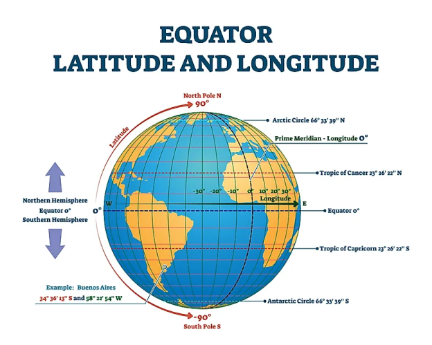
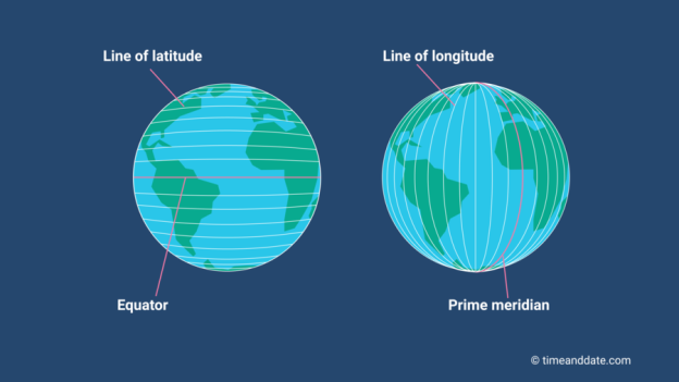
In simple terms, latitudes are imaginary horizontal lines that circle the Earth parallel to the equator.
The equator, located at 0 degrees latitude, serves as the starting point, dividing the Earth into the Northern Hemisphere and the Southern Hemisphere.
As we move north from the equator, latitudes increase, while moving south results in decreasing latitudes.
Each degree of latitude is further divided into 60 minutes and each minute into 60 seconds.
Complementing the latitudes, longitudes form the vertical lines of the global grid system.
These lines run from the North Pole to the South Pole and intersect at the Prime Meridian, which is located at 0 degrees longitude.
Similar to latitudes, each degree of longitude is divided into minutes and seconds.
The Prime Meridian acts as the reference point for all other longitudes, creating a standardized system for measuring locations around the world.
How Latitudes and Longitudes Work Together:
The combination of latitudes and longitudes allows us to pinpoint any location on Earth with remarkable accuracy.
To express a specific location, we use a pair of coordinates, consisting of a latitude value followed by a longitude value.
For example, the coordinates of Bangalore are approximately 12.9716° N (Latitude), 77.5946° E (Longitude).
These coordinates are often represented in two formats: the degrees, minutes, and seconds format, or the more straightforward decimal degrees format.
Importance and Applications:
The significance of latitudes and longitudes extends far beyond just identifying places on a map. These geographical coordinates have numerous practical applications in various fields:
Historical Significance
The concept of latitudes and longitudes has a rich history dating back to ancient civilizations.
Early astronomers and geographers recognized the need for a standardized system to describe locations on Earth accurately.
The ancient Surya Siddhanta book, a book on astronomy talks about the concepts of latitudes and longitudes.
Longitude is termed ” Lambamsa ” and Latitude is termed ” Akshamsa “, also the words “Charardha-Desandara ” is used instead of the former in some ancient texts.
Desandara means the distance (difference) between two specific longitudes; the distance between two places.
Ancient Siddhantas (astronomical texts), and Puranas mention these words to refer to locations.
It becomes evident that the concept of Longitude-Latitude originated in India from these books and puranas!
However the western world credits the Greek astronomer Hipparchus with creating one of the earliest coordinate systems around 150 BCE.
Centuries later, the development of accurate timekeeping devices, such as the chronometer, further improved the accuracy of the global coordinate system.
Challenges and Limitations
While latitudes and longitudes provide an efficient and widespread means of geolocation, they are not without challenges.
One common issue is the distortion of maps and projections, particularly for representing the curved Earth on flat surfaces.
Additionally, converting between different coordinate systems can be complex, and slight inaccuracies can lead to significant errors in certain applications.
Conclusion:
Latitudes and longitudes are the backbone of modern geolocation, enabling us to explore the world and access a wide range of services. Understanding these geographical coordinates unlocks a wealth of information about our planet’s surface, making them indispensable in navigation, weather forecasting, map-making, and various other fields. As we continue to advance technologically, the importance of these coordinates will only grow, fostering a deeper appreciation for the global grid that guides us through our interconnected world. So, let us embrace the power of latitudes and longitudes and navigate our way to new horizons.