India is situated on a huge tectonic plate that continues to crush into Asia at a speed of nearly 5 centimeters per year causing earthquakes.
The Himalayan mountain range is a result of that collision, and the process is still going on.
Here is a detailed explanation of the mechanism of earthquakes, the reasons behind the location of seismic spots in India, the main takeaways from the four significant earthquakes in India with respect to seismic characteristics, and the notion of ground under a city as a factor more important than distance from the epicenter.
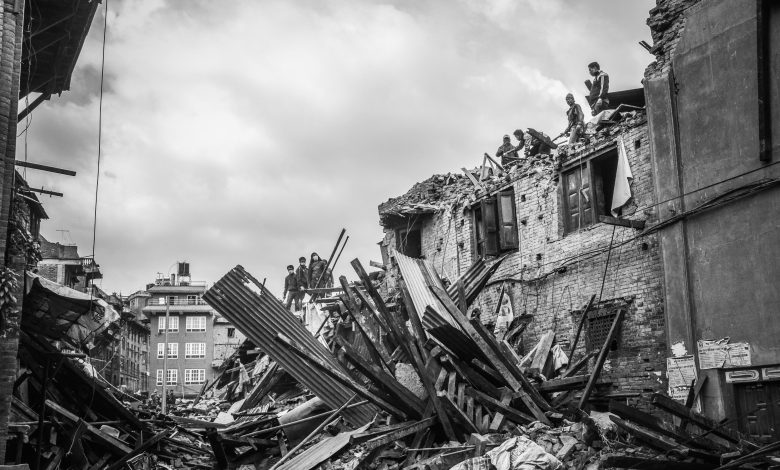
Earthquakes hit Now what?
You’re comfortable at your desk or in bed, and the whole building starts to move.
The fan spins, the water in your glass moves, and your phone keeps buzzing with people asking “did you feel that?”
Then after a few minutes, you see a social media post that it was an earthquake, the magnitude being something, point, something, and the location of a place you may or may not have heard of.
Generally, people understand earthquakes as “tectonic”.
The Earth’s crust is divided into plates, these plates move, and earthquakes happen at the boundaries, which is correct to a point.
But there are quite a few important details left out. Some of India’s deadliest earthquakes have been located hundreds of kilometres away from plate boundaries.
Besides, it has been observed that larger cities closer to the epicentre were left relatively unscathed unlike the smaller ones which were quite devastated by the same earthquake.
Even there, the textbook versions don’t have the parts that really decide if the earthquake will just shake your windows or be the reason for a total destruction of your neighborhood.
Therefore first we are going to set the scene correctly. At the end of this article, you will know the physical causes of the earthquakes, why India’s geological features make certain areas more prone to earthquakes, what information the past earthquakes give us about the risks, and also what scientists know about the ones that have not taken place yet.
What actually happens during an earthquake
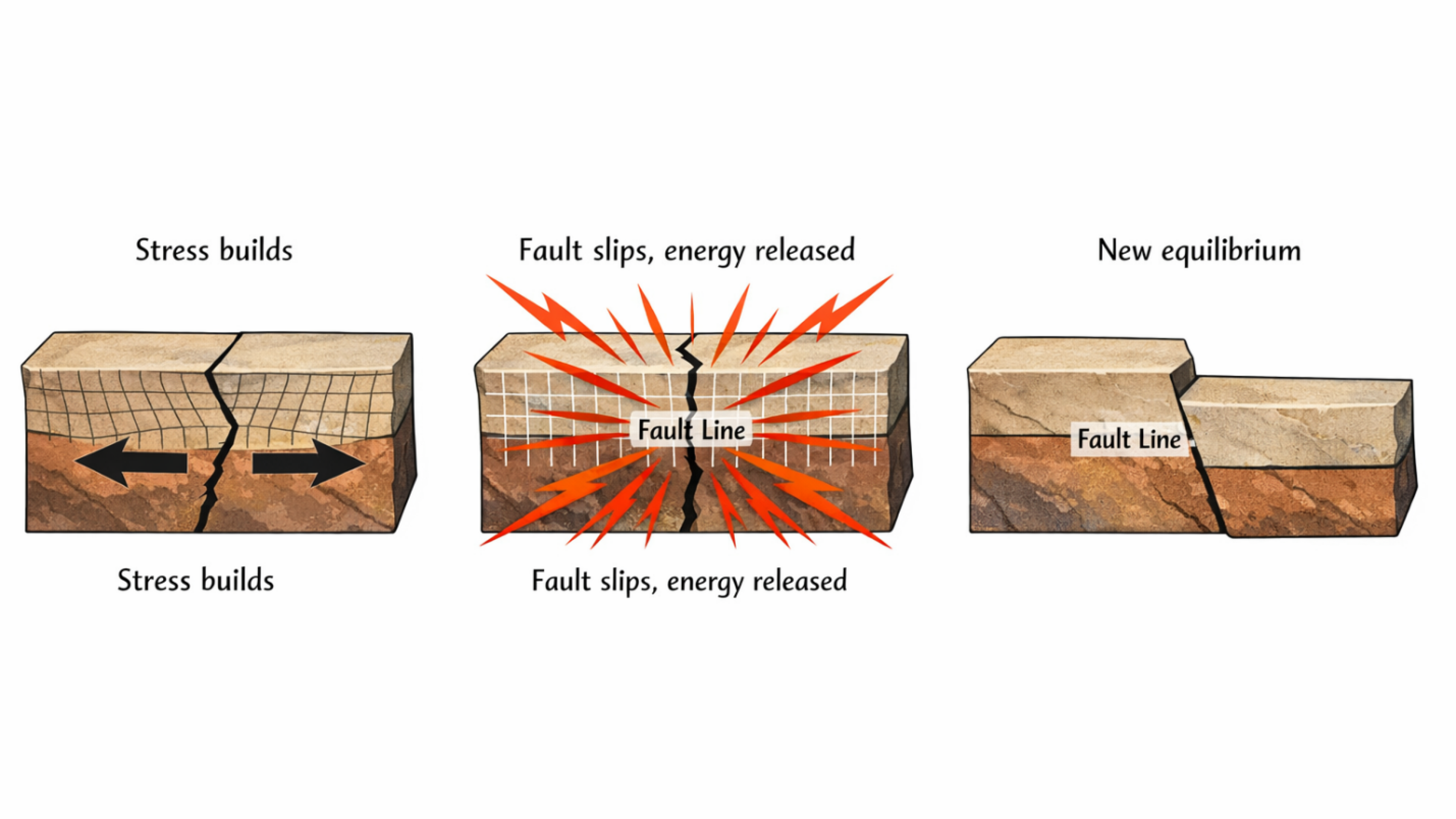
An earthquake begins with a simple physical process. Deep underground, tectonic forces constantly push, pull, and twist rock.
Where two masses of rock meet at a fault, friction locks them in place. But the tectonic stress does not stop just because the fault is stuck. The rocks on either side keep deforming, bending, and storing elastic energy like a stick being flexed.
At some point, stress exceeds friction. The fault slips. The bent rocks snap back toward their original shape, releasing all that stored energy at once.
Geologists call this elastic rebound. It is the fundamental mechanism behind nearly every earthquake on the planet.
That sudden energy release sends waves radiating through the Earth. These seismic waves are what you actually feel when the ground shakes. There are three main types, and they arrive in a specific order.
P-waves (primary waves) are the fastest. They compress and expand rock in the direction they travel, like slinkies pushed from one end.
They pass through solids and liquids, and they reach you first. If you have ever felt a sharp, sudden jolt before the main shaking starts, that was likely a P-wave.
Secondary waves come next. They are slower but more destructive. They shake the rock sideways, perpendicular to the direction of travel, like a rope being flicked.
S-waves cannot pass through liquids. This, incidentally, is one of the ways we know Earth’s outer core is molten.
Surface waves arrive last. Love waves and Rayleigh waves travel along the Earth’s surface, producing the long, rolling motion that topples buildings.
They are the slowest of the three, but they have the most energy at the surface and cause the most damage.
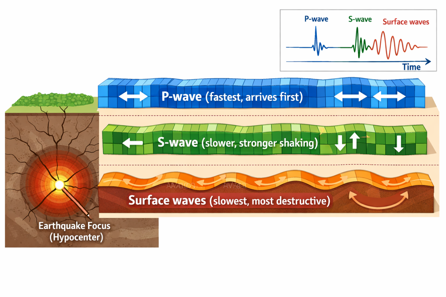
This sequence is relevant for a practical reason. When you feel an earthquake, you are feeling these waves arrive one after another: a jolt (P-wave), then a stronger sideways shake (S-wave), then sustained rolling (surface waves).
The time gap between the P and S arrivals tells seismologists how far you are from the source.
One more distinction is worth understanding: magnitude versus intensity.
Magnitude measures the total energy released at the source. It is a single number for any given earthquake. The moment magnitude scale (Mw) is logarithmic.
Each whole number increase means roughly 32 times more energy. So a magnitude 7 earthquake releases about 1,000 times more energy than a magnitude 5.
Intensity, on the other hand, measures the shaking felt at a specific location. The same earthquake can produce intensity X near the epicenter and intensity V a few hundred kilometers away. Intensity depends on distance, depth, and, critically, the type of ground you are standing on.
This last factor turns out to be one of the most important variables in earthquake damage. We will return to it.
Why India? The plate that is still moving
About 140 million years ago, the Indian landmass broke away from the ancient supercontinent Gondwana and began drifting northward.
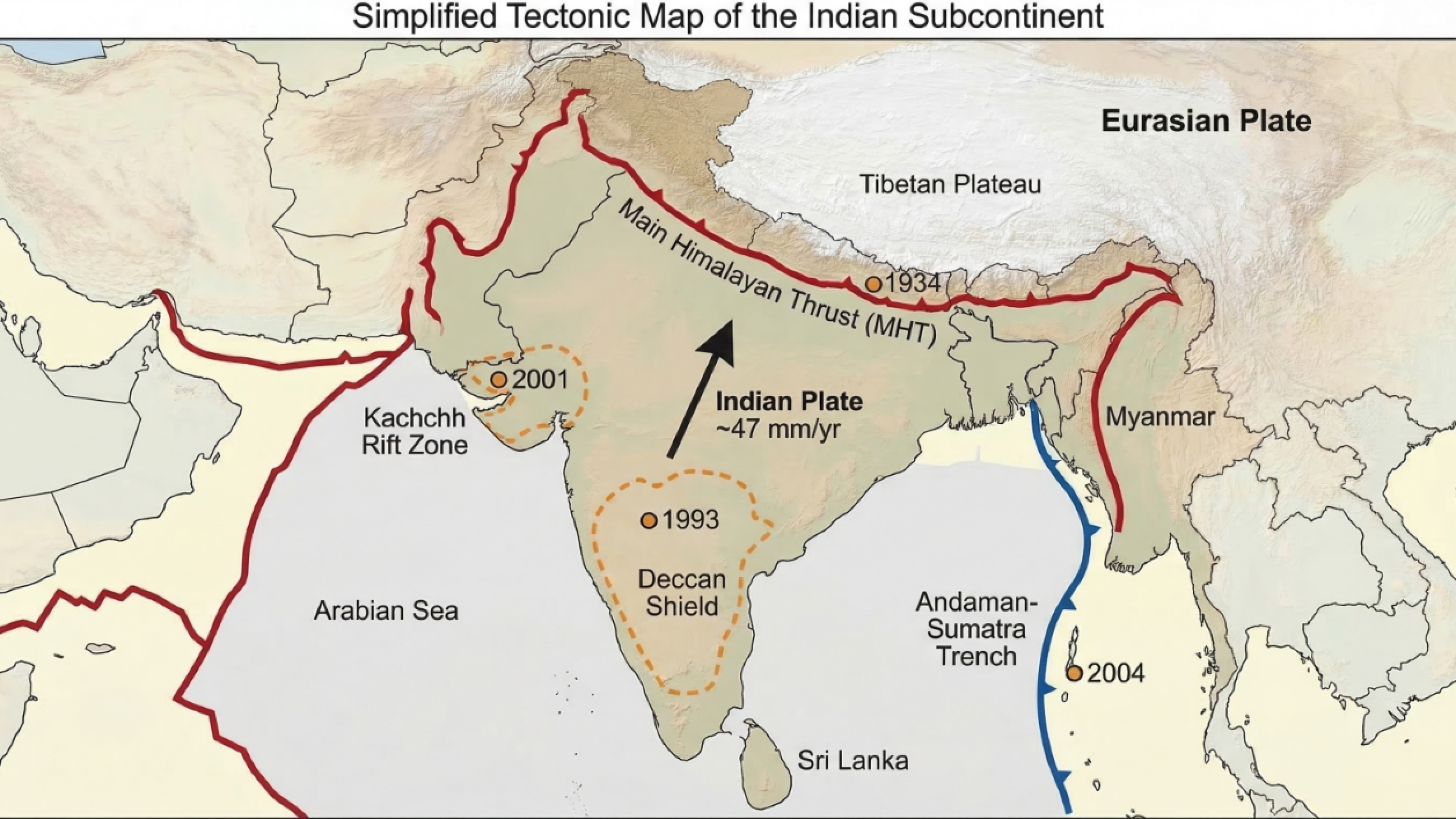
Around 50 million years ago, it collided with Eurasia. That collision has never stopped. Today, the Indian plate continues pushing into Eurasia at roughly 47 millimeters per year.
This ongoing convergence is the engine that drives most of India’s seismic activity and has produced the Himalayas and the Tibetan Plateau.
Beneath the mountains, the Indian plate’s crust is being forced northward under Eurasia along a giant fault system called the Main Himalayan Thrust, or MHT.
GPS stations across the arc record 15 to 50 millimeters per year of crustal shortening, depending on the segment.
Much of this motion is locked. The fault is stuck, building up strain that will eventually release in a large earthquake.
The 1934 Bihar-Nepal and 2015 Gorkha earthquakes both ruptured sections of this locked megathrust.
India’s eastern boundary is a different system entirely. Off the Andaman and Nicobar Islands, the Indian plate dives beneath the Burma-Sunda microplates along the Andaman-Sumatra subduction trench.
This action produced the catastrophic 2004 magnitude 9.1 earthquake and tsunami. The subduction here is oblique, meaning the plates are not just converging but also sliding past each other, creating a complex web of stresses.
But here is what surprises most people. India also experiences significant earthquakes far from any plate boundary.
The 2001 Bhuj earthquake in Gujarat (magnitude 7.6) and the 1993 Latur earthquake in Maharashtra (magnitude 6.2) both struck deep in the peninsula, hundreds of kilometers from either the Himalayan collision zone or the Andaman trench.
These are intraplate earthquakes. They happen because the Indian plate is not a rigid slab.
It contains ancient rift structures, old suture lines, and buried faults from geological events hundreds of millions of years older than the Himalayan collision.
GPS data shows that even “stable” peninsular India accumulates strain at 1 to 2 millimeters per year. That sounds tiny, but over centuries it adds up.
So India’s seismic reality has three faces: the Himalayan collision zone in the north, the Andaman subduction zone in the east, and a scattering of ancient faults across the peninsula that can reactivate without warning.
Each produces a different kind of earthquake, with different characteristics and risks.
What past earthquakes tell us
The best way to understand India’s seismic character is to look at what has already happened.
Four earthquakes, spread across different decades and parts of the country, show the range of threats the country faces.
1934 Bihar-Nepal (Mw 8.1): when the Himalayan thrust breaks
On 15 January 1934, a massive earthquake struck the India-Nepal border.
It ruptured roughly 150 kilometers of the Main Himalayan Thrust at shallow depth. Modern analysis places the epicenter beneath the Nepalese Himalaya, with about 5 to 6 meters of slip along the fault.
What makes this earthquake especially instructive is not the rupture itself but where the worst damage showed up.
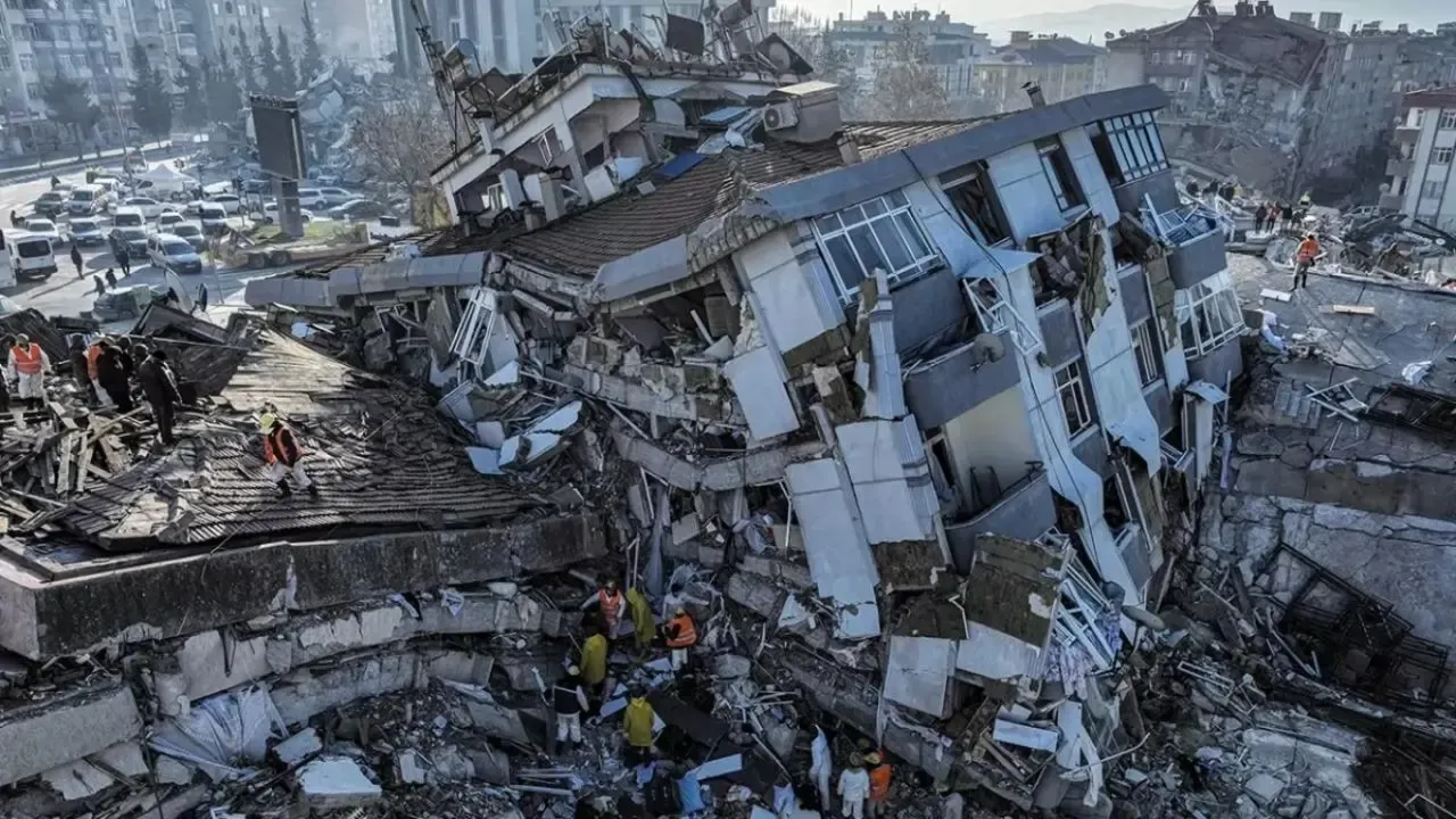
The most extreme shaking (intensity IX to X) was recorded not in the mountains near the epicenter, but in the Gangetic basin of Bihar, over a hundred kilometers to the south.
The soft alluvial soils of the Ganges floodplain amplified the seismic waves and caused widespread liquefaction.
The ground behaved like a liquid. Sand boils erupted across fields. River levees sank. Survey benchmarks dropped by more than a meter.
The 1934 earthquake demonstrated that Himalayan thrust events can devastate the lowlands far more severely than the mountains.
It also introduced the concept of a “seismic gap” into Indian earthquake science. The segment east of this rupture has not broken in recorded history, and strain continues to accumulate.
2001 Bhuj, Gujarat (Mw 7.6): the shock from within
On 26 January 2001, a devastating earthquake struck Gujarat’s Kachchh region, killing approximately 20,000 people.
This was not a plate-boundary event. It occurred on a previously unknown south-dipping fault that parallels ancient rift structures in the basement rock.
The fault plane was roughly 141 kilometers long and 18 kilometers wide, with localized slip reaching 9.7 meters.
No surface rupture was visible. This was a blind thrust: the fault never broke through to the surface.
Ground shaking reached intensity IX to X in Bhuj city. The secondary effects were equally devastating.
Extensive liquefaction hit the Rann of Kutch and Banni grasslands. Sand fountains 2 to 3 meters high erupted from the ground.
Kandla Port, one of India’s major cargo hubs, suffered serious subsidence. Thousands of homes and critical infrastructure collapsed.
Bhuj shattered the comfortable assumption that India’s interior is seismically “safe.” The Kachchh rift dates to the Mesozoic era, over 100 million years old, yet it remains capable of producing high-energy earthquakes. Ancient geology is not dead geology.
2004 Sumatra-Andaman (Mw 9.1): the megathrust and the ocean
The 26 December 2004 earthquake off northwest Sumatra was one of the largest ever recorded.
The rupture extended roughly 1,200 kilometers along the Indo-Australian and Burma plate interface, generating tsunami waves that reached heights of 30 meters in some locations.
For India, the most direct impact was on the Andaman and Nicobar Islands, sitting directly above the northern continuation of the rupture. Tsunami waves reached the islands within minutes.
Wave heights of 10 to 12 meters struck Little Andaman and Car Nicobar. Entire villages were inundated.
Over 300 confirmed deaths occurred on Katchal Island alone. The disaster also impacted the southeastern coast of mainland India, specifically Tamil Nadu.
Before 2004, India had no tsunami early warning system. The event forced the country to confront a category of seismic risk it had largely ignored: oceanic subduction and transoceanic tsunamis.
It led directly to the creation of the Indian Tsunami Early Warning System, operated by INCOIS.
1993 Latur, Maharashtra (Mw 6.2): the “impossible” earthquake

By the standards of major earthquakes, magnitude 6.2 is moderate. But when the Latur earthquake struck the Deccan Shield of central Maharashtra on 30 September 1993, it killed approximately 10,000 people.
The death toll had less to do with the earthquake’s size and everything to do with where and how it struck.
The rupture occurred at about 10 kilometres depth on a previously unidentified fault in Proterozoic basement rock.
This is the ancient core of the Indian peninsula. The epicentral area, built on Deccan flood basalts with poor soil conditions, saw roughly a third of all structures collapse.
Some researchers debated whether reservoir loading from the Terna River dam may have played a role, though the evidence remains inconclusive.
The earthquake is now largely attributed to natural intraplate stress release.
Latur’s lesson was blunt. Even regions classified as “low risk” on seismic maps can host deadly earthquakes.
The Deccan Shield, often treated as geologically quiet, clearly is not. And when non-engineered buildings meet even moderate ground shaking, the results are catastrophic.
Latur forced India to reassess how it thinks about seismic risk in the peninsular interior.
Two other historical earthquakes deserve mention.
The 1897 Shillong Plateau earthquake (Ms 8.7) in Northeast India ruptured a concealed south-dipping fault (later named the Oldham Fault) with up to 16 metres of slip.
It showed that large, hidden faults exist within India’s interior blocks, not just at plate margins.
The 1905 Kangra earthquake (Mw 7.8) in the western Himalaya killed around 20,000 people and revealed that Himalayan earthquakes can rupture in segments without producing surface scarps, making them harder to study.
The Kangra event also raised a question still unanswered: did the 1905 rupture release all accumulated strain in that segment, or is there still enough left for another large event?
Why some cities shake harder than others
Here is something the magnitude number on the news will not tell you. Two cities at equal distance from the same earthquake can experience vastly different shaking. The reason is the ground beneath them.
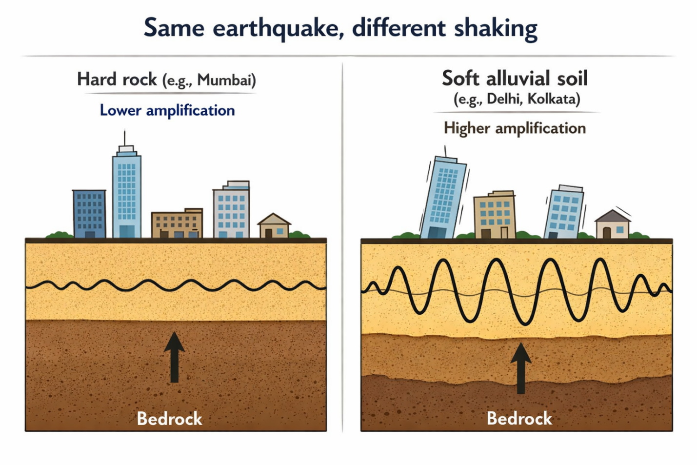
Seismic waves behave differently depending on the material they pass through. When waves travel from hard bedrock into soft, loose sediment, they slow down and their amplitude increases, sometimes dramatically.
Think of a wave moving from deep water into a shallow bay: as depth decreases, the wave height grows.
The same principle applies underground. Soft alluvial soils amplify seismic waves. Hard rock attenuates them.
This has direct consequences for Indian cities. Delhi sits on a deep sedimentary basin that amplifies short-period seismic motions.
Studies show that varying subsurface layers beneath Delhi produce significant amplification.
Tall buildings are particularly at risk because their natural resonance period can match the amplified wave frequencies. Guwahati and the Brahmaputra Valley have thick river deposits that prolong shaking, a factor that contributed to extreme damage in historical Assam earthquakes.
Mumbai and parts of Punjab, built on harder rock and basalt, attenuate waves more quickly and tend to experience lower intensities from the same events.
Then there is liquefaction. When saturated, loose soil loses its structural strength during shaking and behaves like a thick liquid.
Buildings tilt, roads crack, sand boils erupt from the ground. The 2001 Bhuj earthquake triggered liquefaction across the Rann of Kutch, with sand fountains reaching 2 to 3 metres.
The 1934 Bihar earthquake caused benchmark offsets of over a metre in the Gangetic alluvium.
Cities like Kolkata and Surat, built on deltaic and coastal sediments, face similar exposure.
Himalayan valley towns have yet another problem: basin resonance.
Srinagar, Dehradun, and other foothill cities sit in deep basins that can trap seismic waves, bouncing them back and forth, producing prolonged and complex shaking.
Microzonation studies across India consistently find the same thing: soft soils, whether floodplain, delta, or colluvium, significantly increase ground acceleration and building damage compared to rock.
The earthquake does not change. The ground you stand on decides how bad it feels.
India’s seismic zones: what the map actually means
India’s Bureau of Indian Standards maintains a seismic zonation map (IS 1893, last updated in 2016) that divides the country into four hazard zones, numbered II through V, where zone V is the highest expected shaking and zone II is the lowest.
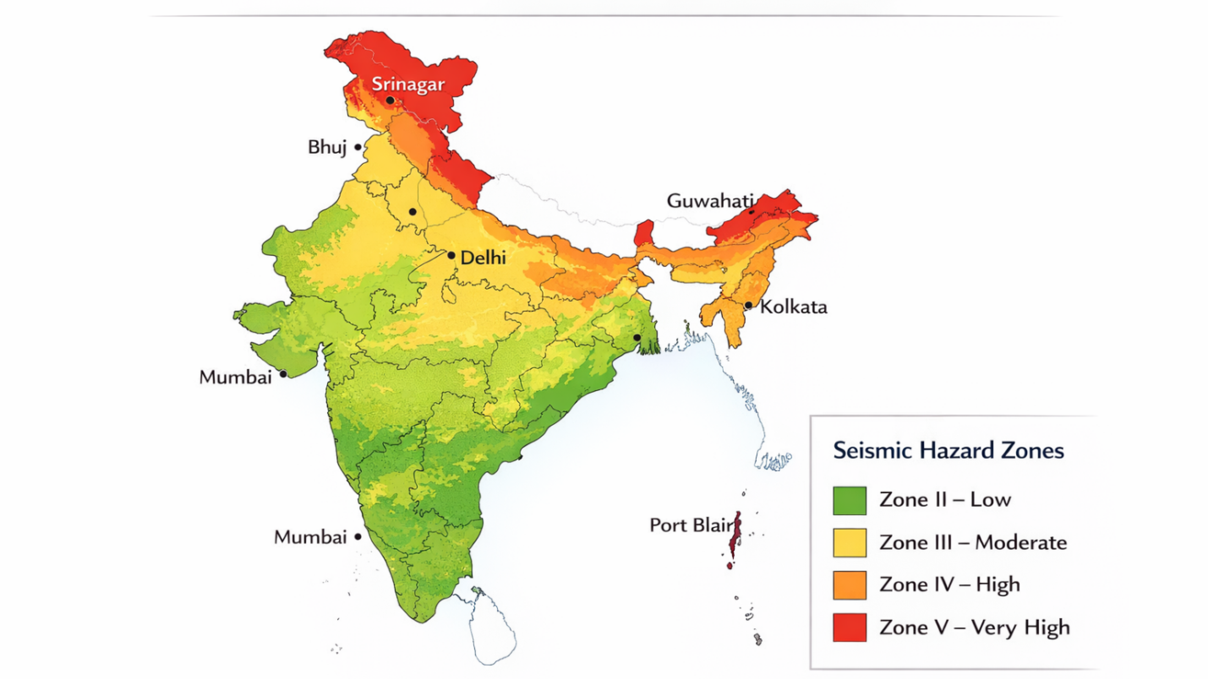
Zone V covers Kashmir, the western and central Himalayas, North Bihar, all of Northeast India, the Rann of Kutch in Gujarat, and the Andaman and Nicobar Islands.
Zone IV includes the eastern Himalayan foothills and some parts of South India, notably the Koyna region in Maharashtra. Zones II and III cover most of peninsular India and the majority of coastal areas.
These zones set the seismic design requirements for buildings under the national code. A structure in Zone V must handle significantly higher lateral forces than one in Zone II. In principle, this is how geological knowledge becomes engineering practice.
In practice, the map has real limitations. It is a broad-brush tool. Zone boundaries do not capture local soil effects, which can amplify shaking by factors of two or more.
The historical seismic record behind the map is incomplete, especially for regions with long recurrence intervals. The Latur earthquake struck in what was then a Zone I area (since upgraded). And the map says nothing about building quality or code enforcement, which is where most earthquake deaths actually originate.
Seismic microzonation, a finer-grained mapping of site-specific hazard, is underway in several major cities, including Delhi, Mumbai, Kolkata, Guwahati, and Chennai.
These studies account for local soil conditions, bedrock depth, and basin geometry. They are more useful for urban planning than the national map, but they remain incomplete. The zonation map is a starting point, not a safety guarantee.
What comes next: the earthquakes India has not had yet
Scientists cannot predict when a specific earthquake will strike. But they can identify where strain is building and estimate how much energy a fault segment could release.
In India, several of these assessments point toward serious future risk.
The most widely discussed concern is the Himalayan seismic gap. Much of the Himalayan arc has ruptured in the past century or so: 1897 in the Shillong Plateau, 1905 in Kangra, 1934 in Bihar-Nepal, and 1950 in Assam.
But remaining segments, particularly in eastern Nepal and Sikkim and possibly western Nepal, appear to have gone centuries without a major rupture.
Strain has been accumulating throughout. If the westernmost section near Kangra did not fully release its stored energy in 1905, another large event remains possible.
GPS data confirms that these faults are still loading at 15 to 50 millimeters per year.
Intraplate repeat times are longer and harder to pin down. Earthquakes like Latur may have recurrence intervals around 1,400 years.
Kachchh-type events, given the 1819 Rann of Kutch earthquake, may recur on timescales of 1,000 to 1,500 years.
These are rough estimates with large uncertainty bands. But they do establish that intraplate faults are not one-off events.
What makes these risks particularly alarming is the growth of urban exposure.
A magnitude 7 or greater earthquake near Delhi-Punjab could endanger more than 20 million people, many of them in buildings that were never designed or constructed to seismic codes.
Nuclear power plants sit in Zones IV and V. Major dams like Tehri, Bhakra, and Koyna are in seismically active regions. Kandla port, already damaged in 2001, remains in a high-hazard zone.
No major earthquake in living memory has tested the water supply systems, highways, and bridges across northern India.
India’s National Disaster Management Authority has published guidelines, run drills, and begun pushing for earthquake early warning systems. But implementation remains patchy.
Building code enforcement is weak in many states. Earthquake early warning, which uses the few seconds between P-wave detection and destructive S-wave arrival to trigger alerts, is still nascent.
The gap between what the science tells us and what the country has done about it is large.
The ground will shake again
India’s geology guarantees future earthquakes. The Indian plate is still moving. The Himalayan megathrust is still locked.
Ancient faults in the peninsula are still under stress. None of this is speculation. It is plate tectonics.
Ultimately, the boundary between a manageable tremor and a catastrophic disaster is defined by the specific geological composition of the ground and the robustness of the structural environment built upon it.
Building codes, seismic zonation maps, and microzonation studies for major cities all exist. Science is not the bottleneck. The bottleneck is translation: turning geological knowledge about engineered structures, sensible land-use planning, and public awareness that outlasts the few minutes after a tremor.
The next time you feel the ground move, you now know what is happening beneath you. Elastic strain is released at a fault.
Seismic waves arriving in sequence. Local soil conditions are shaping how those waves reach your building. And behind all of it, a tectonic plate that has been moving for 140 million years and shows no sign of slowing down.